Intense Heat Moving Deeper into the South in Coming Days
Over 120 million Americans are under heat alerts this weekend as record temperatures engulf the Mid-Atlantic and Southern regions.
Heat Alerts for the I-95 Corridor
The I-95 corridor, stretching from New York City to Virginia, is sweltering this weekend. New York faces an Extreme Heat Risk on Saturday, extending to the entire corridor on Sunday.
In New York City, the heat index could climb to 103 degrees, potentially tying the daily record high of 96 degrees on Sunday. Philadelphia’s heat index may reach 102 degrees on Saturday, rising to 110 degrees on Sunday, with a possible record high of 98 degrees.
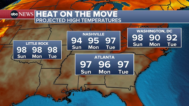
Washington, D.C. is forecasted to have a heat index between 105 and 110 degrees on Saturday, with highs nearing 100 degrees both days. On Sunday, D.C.’s heat index could hit 104 degrees. Baltimore will experience similar extreme temperatures, nearing record levels.
Air Quality Concerns
Air Quality Alerts are also in place for much of this region due to stagnant air causing high levels of low-level ozone, posing health risks to vulnerable groups, including children, the elderly, and individuals with respiratory conditions.
Heat Spreads into the South
The severe heat is expected to move further into the South in the coming days, potentially providing some relief to parts of the Northeast. However, this will bring difficult conditions to new areas.
Western Heat Alerts
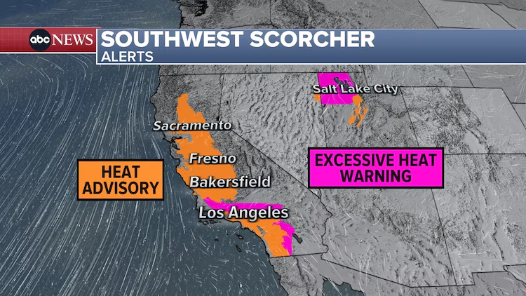
Heat alerts are also active across central and southern California, and parts of Utah, including Salt Lake City. In Palm Springs, temperatures could hit 114 degrees from Saturday through Thursday, prompting an Excessive Heat Warning.
Redding and Sacramento are forecasted to reach up to 107 degrees on Saturday, while Fresno may see temperatures rising to 108 degrees on both Saturday and Sunday. Salt Lake City is expected to reach around 100 degrees on Sunday, under an Excessive Heat Warning.
Severe Storms and Flooding
Severe thunderstorms and significant flooding have been occurring from the Upper Midwest to the Northeast due to storms developing along the northern edge of the heat dome.
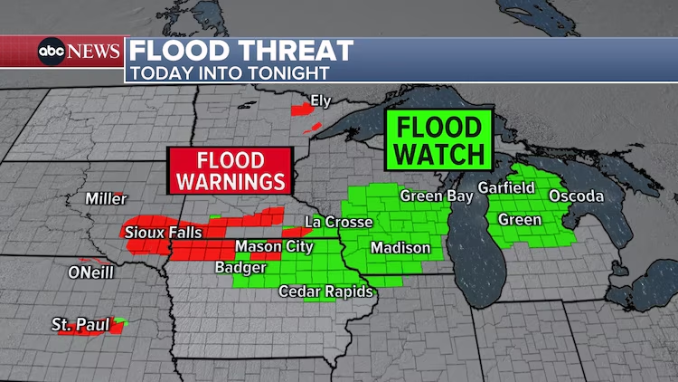
Northern Iowa has experienced heavy rainfall along a stalled front, resulting in 4-8 inches of rain within 24 hours, causing major flooding.
Over the past three days, parts of South Dakota, Nebraska, and Iowa have received over 6 inches of rain, with a narrow area south of Sioux Falls reporting 10-15 inches.
Numerous Flood Alerts remain in effect, with several rivers reaching major flood stage.
Southern Wisconsin could see an additional 1-3 inches of rain for the rest of Saturday into the night, increasing the risk of flooding.
Severe storms are also expected in the Upper Midwest, with damaging winds and flash flooding threatening cities like Chicago, Milwaukee, and Des Moines.
Tropical Update
In the tropics, an area of interest around the Bay of Campeche in the southern Gulf of Mexico has a 40% chance of developing into a named storm, potentially Beryl. However, this storm is not expected to make landfall in the United States, though it could bring heavy rain to south Texas.
Coastal Storm Developments
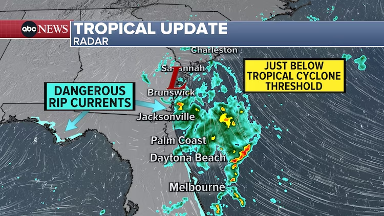
A small storm off the coast of Georgia showed potential to become a named tropical system on Friday but did not fully develop. Despite this, the storm brought rain to the Southeast, along with high surf and a rip current risk.
Safety Measures
Authorities advise residents in affected areas to take necessary precautions to protect themselves from the extreme heat and related health risks.
Recommendations include staying hydrated, remaining in air-conditioned spaces, avoiding strenuous activities during peak heat hours, and wearing lightweight, light-colored, loose-fitting clothing.
It is also important to check on vulnerable individuals, such as the elderly, children, and pets.
Air Quality Precautions
Residents should stay indoors and keep windows closed to reduce exposure to outdoor air. Using air purifiers can help improve indoor air quality. It is important to monitor for symptoms such as coughing, shortness of breath, and eye irritation.
Conclusion
The ongoing heatwave and severe weather conditions are presenting significant challenges across the United States this weekend.
Staying informed and taking necessary precautions can help mitigate the risks associated with these extreme temperatures and severe weather events.
Residents are advised to stay safe, stay cool, and keep an eye on weather updates for the latest information.
Source: abc News
You can Visit Our Social Pages:


To get our services:


